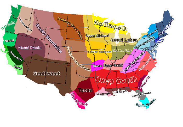
I’ve never heard half of these names used like this.
“Chesapeake”… First I’ve never heard it used as a region, second the region so labeled on the map would be better called Mid-Atlantic (and that wouldn’t really be accurate either) that really is the Mid-Atlantic region, and there’s no Mid-Atlantic on this map, but there’s a Mid-Atlantic South (which I’ve never heard anyone use - VA is Mid-Atlantic).
Third, the Chesapeake doesn’t even extend to PA, let alone up to NY or Jersey, over there is the Delaware Bay, so should we call that region “Delaware”?
I’ve never once heard anyone call that region Chesapeake - it’s the Mid-Atlantic.
Then there’s the Texas nonsense - there’s West Texas, Central, East (sometimes jokingly referred to as Arkansas) I’ll allow Rio Grande though I’ve never heard that used.
The West stuff… Yea, no. The Rockies, OK.
A source would be useful, perhaps knowing the context (like how this is used) would clarify things.
Also, it looks like the “Central Valley” in CA extends uphill to the top of the Sierras and Lake Tahoe. Plus “Socal” is as far north as Carmel.
No. Carmel is the Central Coast. You might as well add that to the Central Valley and add some new group for the Sierra Nevada mountains that includes northern CA above Sacramento. The north coast is culturally and geographically similar to the Sierras. “Socal” doesn’t extend farther north than Santa Barbara.
A lot of those are overlapping, like Appalacha and the Great Lakes both extend into Upstate NY, much of lower Appalacha is also considered mid-atlantic, etc
I agree, but also they’re different regions on this map. I’m more upset about being lumped in with Dallas. Ultimately when you’re pumping large areas together, there are going to be dissimilar places within it, but they might also be more similar than some of us care to admit
I grew up in the Deep South part of Texas and moved to and currently live in Texas Texas. I have a lot of feelings about this map that I can’t really convey.


Central Texas is nothing like East Texas, so that makes the rest of this map suspect.
Yea, this map is nonsense.
I’ve never heard half of these names used like this.
“Chesapeake”… First I’ve never heard it used as a region, second the region so labeled on the map would be better called Mid-Atlantic (
and that wouldn’t really be accurate either) that really is the Mid-Atlantic region, and there’s no Mid-Atlantic on this map, but there’s a Mid-Atlantic South (which I’ve never heard anyone use - VA is Mid-Atlantic).Third, the Chesapeake doesn’t even extend to PA, let alone up to NY or Jersey, over there is the Delaware Bay, so should we call that region “Delaware”?
I’ve never once heard anyone call that region Chesapeake - it’s the Mid-Atlantic.
Then there’s the Texas nonsense - there’s West Texas, Central, East (sometimes jokingly referred to as Arkansas) I’ll allow Rio Grande though I’ve never heard that used.
The West stuff… Yea, no. The Rockies, OK.
A source would be useful, perhaps knowing the context (like how this is used) would clarify things.
Also, it looks like the “Central Valley” in CA extends uphill to the top of the Sierras and Lake Tahoe. Plus “Socal” is as far north as Carmel.
No. Carmel is the Central Coast. You might as well add that to the Central Valley and add some new group for the Sierra Nevada mountains that includes northern CA above Sacramento. The north coast is culturally and geographically similar to the Sierras. “Socal” doesn’t extend farther north than Santa Barbara.
Chesapeake kinda looks like it’s the Chesapeake bays watershed, for what it’s worth.
Yeah… I’ve heard of Cascadia before, but people here would say they’re in the Pacific NW region.
“Cascadia” has some unfortunate connotations in regards to white supremacy (especially in Oregon).
It’s not, which is why it’s not accurate
A lot of those are overlapping, like Appalacha and the Great Lakes both extend into Upstate NY, much of lower Appalacha is also considered mid-atlantic, etc
The map labels central Texas as Texas and east Texas as Deep South. They’re labeled differently. I don’t understand your comment.
I agree, but also they’re different regions on this map. I’m more upset about being lumped in with Dallas. Ultimately when you’re pumping large areas together, there are going to be dissimilar places within it, but they might also be more similar than some of us care to admit
I grew up in the Deep South part of Texas and moved to and currently live in Texas Texas. I have a lot of feelings about this map that I can’t really convey.
Suddenly americans know about geography.
But only places they’ve lived in it known people in.