I wanted to put together a hub of resources for the Line Fire here on Lemmy. I hope this helps anyone who might find it!
⚠
Sort by NEW to see the latest maps/updates!
🗞
Line Fire Updates:
https://www.fire.ca.gov/incidents/2024/9/5/line-fire/updates
The latest updates from the county and state are funneled through here multiple times a day.
🗺
Line Fire Maps:
The latest maps are being curated in the comments below multiple times a day, but the most up-to-date maps should always be the direct sources listed right here:
NOAA fire Map:
https://www.ospo.noaa.gov/products/land/hms.html#maps
The most reliable and frequently updated map that shows satellite readings of fire spread. This includes hotspots outside the perimeter, and a comprehensive smoke plume map.
Official Cal Fire Map:
https://www.fire.ca.gov/incidents/2024/9/5/line-fire
Shows live aircraft positions, and is updated a few times a day. Very reliable and helpful to review evacuation warnings/orders
3D Fire Map by Cal Fire
https://calfire-forestry.maps.arcgis.com/home/webscene/viewer.html?webscene=52683f25df174b0eb124dfb9a6831a98
Not updated more than once or twice a day, but a very cool map to inspect.
CleanAir Fire & Smoke Map
https://fire.airnow.gov/#10.64/34.2049/-116.9408
Updated more often than the Cal Fire map, and shows real-time air quality readings
Historical map of the Big Bear area
https://projects.capradio.org/california-fire-history/#10.76/34.1852/-116.9961/0/1
This is an extremely helpful tool for obtaining visual data of previous wildfire events. The linked map is centered on Big Bear and Arrowhead lake.
📹
Line Fire Webcams
https://ops.alertcalifornia.org/cameras
This network of cameras can be used to easily and intuitively view the fire from multiple angles.
📻
Line Fire Radio
https://scancalifornia.com/live/goldmine/
This covers radio chatter from firefighters tackling the Line Fire.
💬
Community Resources
https://socalmountains.com/e107_plugins/forum/forum.php
A forum for locals that’s been around since 2003
Local Images
https://www.flickr.com/photos/calfire/albums/72177720320272950/with/53989492937
Big Bear City trash pickup was halted on Tuesday, Wednesday and Thursday of this week. Water and Sewer services are all continuing without disruption. (and I haven’t personally experienced any power disruptions yet.)


A new Cal Fire video update has been posted (link below starts at the Big Bear section)
https://youtu.be/meio7RFcZvc?feature=shared&t=210
Formatted transcript:
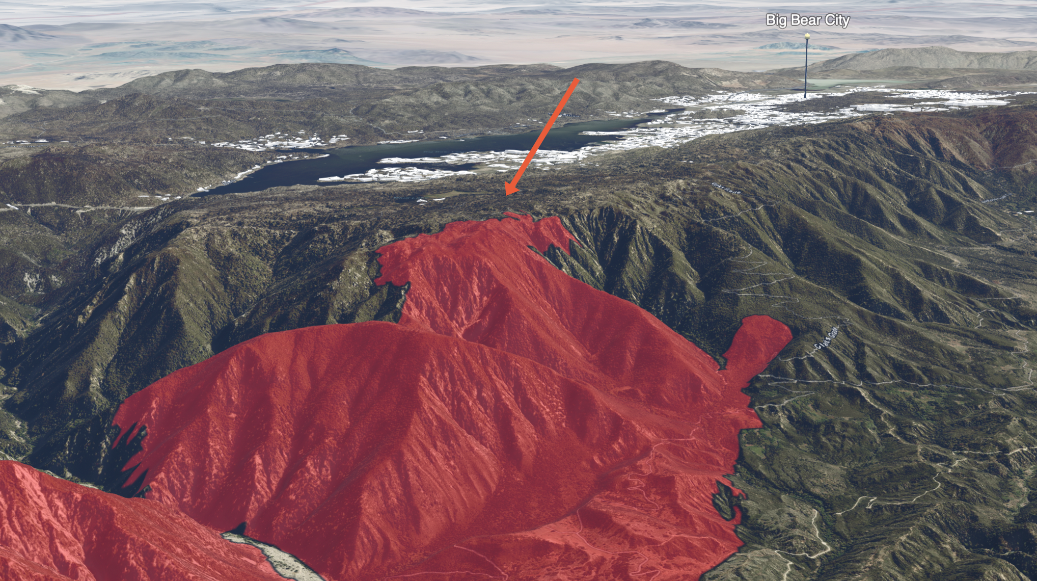
Moving over into the Big Bear drainage, we still have that potential for fire runs up to what we call the plateau, which is right up on the top there where that enormous fuel brake was [created by] the forest service.
Once we get to that piece, that should be able to mitigate any of our problems in the Big Bear area. So, the next two or three days will be critical for that operation.**
I am fairly certain that this below image I created from the Cal Fire 3D map is “The Plateau” mentioned above: