
![[Aug 27] Update: Tropical Storm Idalia (AL10) is predicted to be a Cat 2 hurricane](https://lemmy.world/pictrs/image/18a4f319-8489-4805-96f4-05ad72dd0c30.png)
Idalia’s maximum intensity forecast has been raised slightly to a Cat 2 with predicted sustained winds of 100 mph (85 kts). The forecaster noted that the intensity forecast is somewhat challenging for this storm. See “Discussion Number 5” in the comments for details.
FORECAST POSITIONS AND MAX WINDS
INIT  27/2100Z 20.1N  85.5W   35 KT  40 MPH
 12H  28/0600Z 20.5N  85.3W   45 KT  50 MPH
 24H  28/1800Z 21.7N  85.0W   55 KT  65 MPH
 36H  29/0600Z 23.4N  84.9W   65 KT  75 MPH
 48H  29/1800Z 25.6N  84.5W   75 KT  85 MPH
 60H  30/0600Z 28.7N  83.7W   85 KT 100 MPH
 72H  30/1800Z 31.3N  81.9W   50 KT  60 MPH...INLAND
 96H  31/1800Z 34.5N  76.0W   50 KT  60 MPH...OVER WATER
120H  01/1800Z 35.0N  71.0W   55 KT  65 MPH
Original Post:
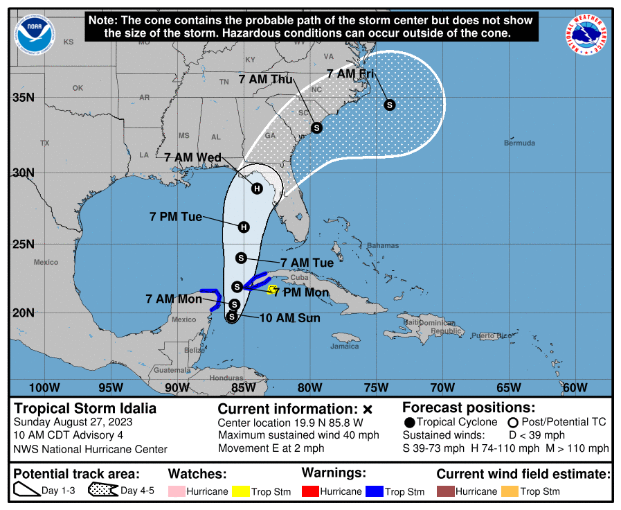
Current predictions from the National Hurricane Center have Tropical Storm Idalia (previously Tropical Depression 10) developing into a Cat 1 hurricane by Tuesday (the next 48 to 72 hours). It’s expected to make landfall in Florida by Wednesday. The official forecast line has it hitting somewhere between Panama City (panhandle) and Tampa Bay (peninsula). The GFS and ECMWF models are mostly predicting landfall around Apalachee bay. These predictions, both the storm track and intensity, may change as the storm develops. When the storm enters the Gulf of Mexico on early Tuesday there will be very warm waters conducive to development, but it will also be under heavy windshear.
FORECAST POSITIONS AND MAX WINDS
INIT  27/0900Z 20.1N  86.8W   30 KT  35 MPH
 12H  27/1800Z 20.1N  86.5W   40 KT  45 MPH
 24H  28/0600Z 20.6N  86.3W   45 KT  50 MPH
 36H  28/1800Z 21.7N  86.3W   50 KT  60 MPH
 48H  29/0600Z 23.3N  86.2W   60 KT  70 MPH
 60H  29/1800Z 25.7N  85.7W   75 KT  85 MPH
 72H  30/0600Z 28.5N  84.7W   80 KT  90 MPH
 96H  31/0600Z 33.0N  81.2W   45 KT  50 MPH...INLAND
120H  01/0600Z 35.0N  75.5W   35 KT  40 MPH...OVER WATER
Resources
- Tropical Storm Idalia - NHC
- CIMSS Tropical Cyclones Group
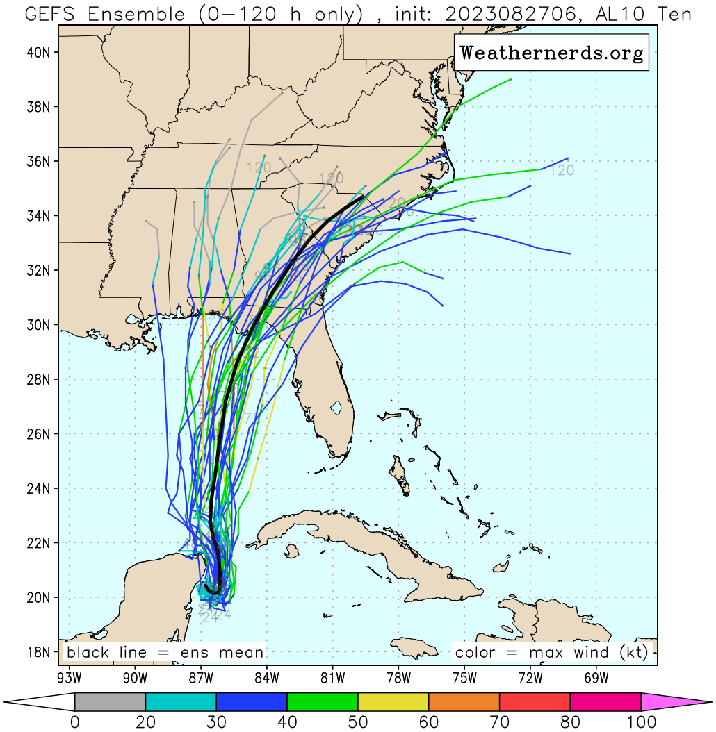
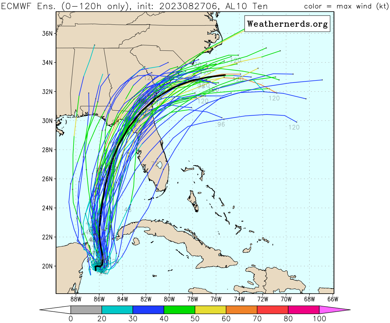
- Ensemble Forecasts for AL10 - Weather Nerds
Previous Discussions
000
WTNT65 KNHC 271513
TCUAT5
Tropical Storm Idalia Tropical Cyclone Update
NWS National Hurricane Center Miami FL AL102023
1015 AM CDT Sun Aug 27 2023
…DEPRESSION STRENGTHENS TO A TROPICAL STORM…
Observations from a NOAA Hurricane Hunter aircraft indicate that Tropical Depression Ten has strengthened into Tropical Storm Idalia. The maximum winds are estimated to be 40 mph (65 km/h) with higher gusts.
SUMMARY OF 1015 AM CDT…1515 UTC…INFORMATION
LOCATION…19.9N 85.8W
ABOUT 80 MI…135 KM ESE OF COZUMEL MEXICO
MAXIMUM SUSTAINED WINDS…40 MPH…65 KM/H
PRESENT MOVEMENT…E OR 90 DEGREES AT 2 MPH…4 KM/H
MINIMUM CENTRAL PRESSURE…996 MB…29.41 INCHES
$$
Forecaster Pasch
000
WTNT45 KNHC 271500
TCDAT5
Tropical Depression Ten Discussion Number 4
NWS National Hurricane Center Miami FL AL102023
1000 AM CDT Sun Aug 27 2023
So far this morning, the overall cloud pattern of the tropical cyclone has not become significantly better organized. The small center is partially exposed on GOES-16 visible imagery, and convective banding features are still not very well defined. The current intensity is held at 30 kt for this advisory which is in line with the latest Dvorak Satellite estimates. A NOAA Hurricane Hunter aircraft, flying at around 12000 ft, is near the center of the system taking Doppler radar wind velocity measurements. These data should provide valuable information on the structure of the cyclone for initializing the numerical weather prediction models.
The center of the cyclone appears to have been moving in a small clockwise loop overnight and into this morning, and it will probably complete this loop today. The initial motion estimate is now around 090/2 kt. Steering currents should remain weak through today and tonight. Beginning on Monday, a mid-level ridge starts to build near southern Florida and eastward. This evolution should cause a generally northward motion during the next couple of days. In 48 to 72 hours, a mid-level trough dropping into the eastern U.S. will likely induce a turn toward the north-northeast and take the system across the northeast Gulf of Mexico coast on Wednesday. The official forecast track has been nudged to the right of the previous one, but is not quite as far east as the latest corrected consensus, HCCA, prediction. Users are reminded not to focus on the exact forecast track, since strong winds, heavy rains and dangerous storm surges extend well away from the center.
The cyclone will be moving over waters of high oceanic heat content over the eastern Gulf of Mexico and within a moist mid- to low-level air mass for the next few days. An upper-tropospheric trough is predicted to develop over the western Gulf of Mexico in 48 to 72 hours. Although this feature could produce some moderate southwesterly vertical wind shear over the system, positive vorticity advection and diffluent upper-level flow to the east of the trough will likely be conducive for strengthening. The official forecast, like the previous one, calls for the cyclone to reach hurricane status over the eastern Gulf of Mexico in 48 to 72 hours. This is at the high end of the latest intensity model guidance.
KEY MESSAGES:
The depression is forecast to become a hurricane over the eastern Gulf of Mexico, and there is an increasing risk of life-threatening storm surge, flooding from heavy rainfall, and hurricane-force winds along portions of the west coast of Florida and the Florida Panhandle beginning as early as Tuesday. Although it is too soon to specify the exact location and magnitude of these impacts, residents in these areas should monitor updates to the forecast, have their hurricane plan in place, and follow any advice given by local officials. Storm surge and hurricane watches may be required for portions of the Gulf coast of Florida later today.
Heavy rainfall is expected across the eastern Yucatan Peninsula and western Cuba and may produce areas of flash and urban flooding and landslides across western Cuba. The depression is forecast to become a tropical storm later today, and tropical storm conditions are expected over portions of the Yucatan Peninsula and extreme western Cuba with tropical storm conditions possible on the Isle of Youth.
Scattered flooding from heavy rainfall is likely over in portions of the southeast U.S. by mid to late week.
FORECAST POSITIONS AND MAX WINDS
INIT  27/1500Z 19.9N  85.8W   30 KT  35 MPH
 12H  28/0000Z 19.7N  85.9W   40 KT  45 MPH
 24H  28/1200Z 20.6N  85.7W   45 KT  50 MPH
 36H  29/0000Z 21.9N  85.5W   50 KT  60 MPH
 48H  29/1200Z 24.0N  85.2W   60 KT  70 MPH
 60H  30/0000Z 26.2N  85.0W   75 KT  85 MPH
 72H  30/1200Z 28.9N  84.0W   80 KT  90 MPH
 96H  31/1200Z 33.0N  79.5W   45 KT  50 MPH...INLAND
120H  01/1200Z 34.5N  74.0W   45 KT  50 MPH...OVER WATER
$$
Forecaster Pasch
ZCZC MIATCDAT5 ALL
TTAA00 KNHC DDHHMM
Tropical Depression Ten Discussion Number 3
NWS National Hurricane Center Miami FL AL102023
400 AM CDT Sun Aug 27 2023
The small circulation of Tropical Depression Ten continues to be well-defined in Cancun radar, with the center moving across Cozumel during the past few hours. Data from a Weatherflow sensor on the island indicated that the pressure dropped to about 1001 mb, with sustained winds of about 30 kt. A small burst of convection has formed just south of the center recently, with scattered banding features in the eastern semicircle. Most of the satellite estimates are just shy of tropical storm strength, so the initial winds speed will stay 30 kt. Both Air Force Reserve and NOAA Hurricane Hunter aircraft will be in the system later this morning to get a better look at the structure and winds.
The depression has turned southward tonight, moving at about 4 kt, apparently rotating around the western periphery of its larger parent circulation to the east. Little net motion is expected for about a day as steering currents remain weak. After that time, a developing trough over the Gulf of Mexico and stronger ridging over the western Atlantic is expected to lift the system toward the north and north-northeast over the eastern Gulf of Mexico. This track takes the system toward Florida, and then near the southeastern coast of the U.S. The overnight model guidance is a bit farther west and slower than the last cycle, probably due to the depression being further south than anticipated. Thus, the NHC forecast is nudged westward, and lies on the east side of the guidance envelope. These are small changes overall, and the track should be considered lower confidence until it starts moving in a more consistent manner. The NOAA G-IV aircraft should be in the area this afternoon to help smooth out the model differences along with special upper-air soundings scheduled across many areas of the southeastern United States.
The very warm and deep waters of the northwestern Caribbean Sea and Gulf of Mexico should support at least gradual strengthening during the next few days, tempered by moderate shear from a flat upper- level trough. However, this trough is forecast to amplify over the western Gulf of Mexico around Tuesday, which causes the shear to decrease near the cyclone in that time frame. There’s a notable risk of rapid intensification while the system moves across the record warm eastern and northeastern Gulf of Mexico, which is highlighted by the recent HAFS and HWRF guidance. The new NHC forecast is raised from the previous one, near or above the model consensus, and could be too low. I’m reluctant to make any big changes to the forecast until we get more in-situ data, but the upward overnight model trend certainly bears watching. Users are reminded to continue monitoring forecasts for any changes to the system’s expected intensity as it approaches Florida.
KEY MESSAGES:
Heavy rainfall from Tropical Depression Ten is expected across the eastern Yucatan Peninsula and western Cuba. The heavy rainfall may produce areas of flash and urban flooding, as well as landslides, across western Cuba. The depression is forecast to become a tropical storm later today, and tropical storm conditions are expected over portions of the Yucatan Peninsula and extreme western Cuba where a Tropical Storm Warning is in effect. Tropical storm conditions are possible on the Isle of Youth, where a Tropical Storm Watch is in effect.
The depression is forecast to strengthen during the next few days and could become a hurricane over the eastern Gulf of Mexico, bringing a potential of dangerous storm surge, heavy rainfall, and strong winds to portions of the west coast of Florida and the Florida Panhandle by the middle of this week. Heavy rainfall is also likely to spread into portions of the Southeast U.S. by mid to late week. Although it is too soon to specify the exact location and magnitude of these impacts, residents in these areas should monitor updates to the forecast of this system and ensure that they have their hurricane plan in place.
FORECAST POSITIONS AND MAX WINDS
INIT  27/0900Z 20.1N  86.8W   30 KT  35 MPH
 12H  27/1800Z 20.1N  86.5W   40 KT  45 MPH
 24H  28/0600Z 20.6N  86.3W   45 KT  50 MPH
 36H  28/1800Z 21.7N  86.3W   50 KT  60 MPH
 48H  29/0600Z 23.3N  86.2W   60 KT  70 MPH
 60H  29/1800Z 25.7N  85.7W   75 KT  85 MPH
 72H  30/0600Z 28.5N  84.7W   80 KT  90 MPH
 96H  31/0600Z 33.0N  81.2W   45 KT  50 MPH...INLAND
120H  01/0600Z 35.0N  75.5W   35 KT  40 MPH...OVER WATER
$$
Forecaster Blake
NNNN