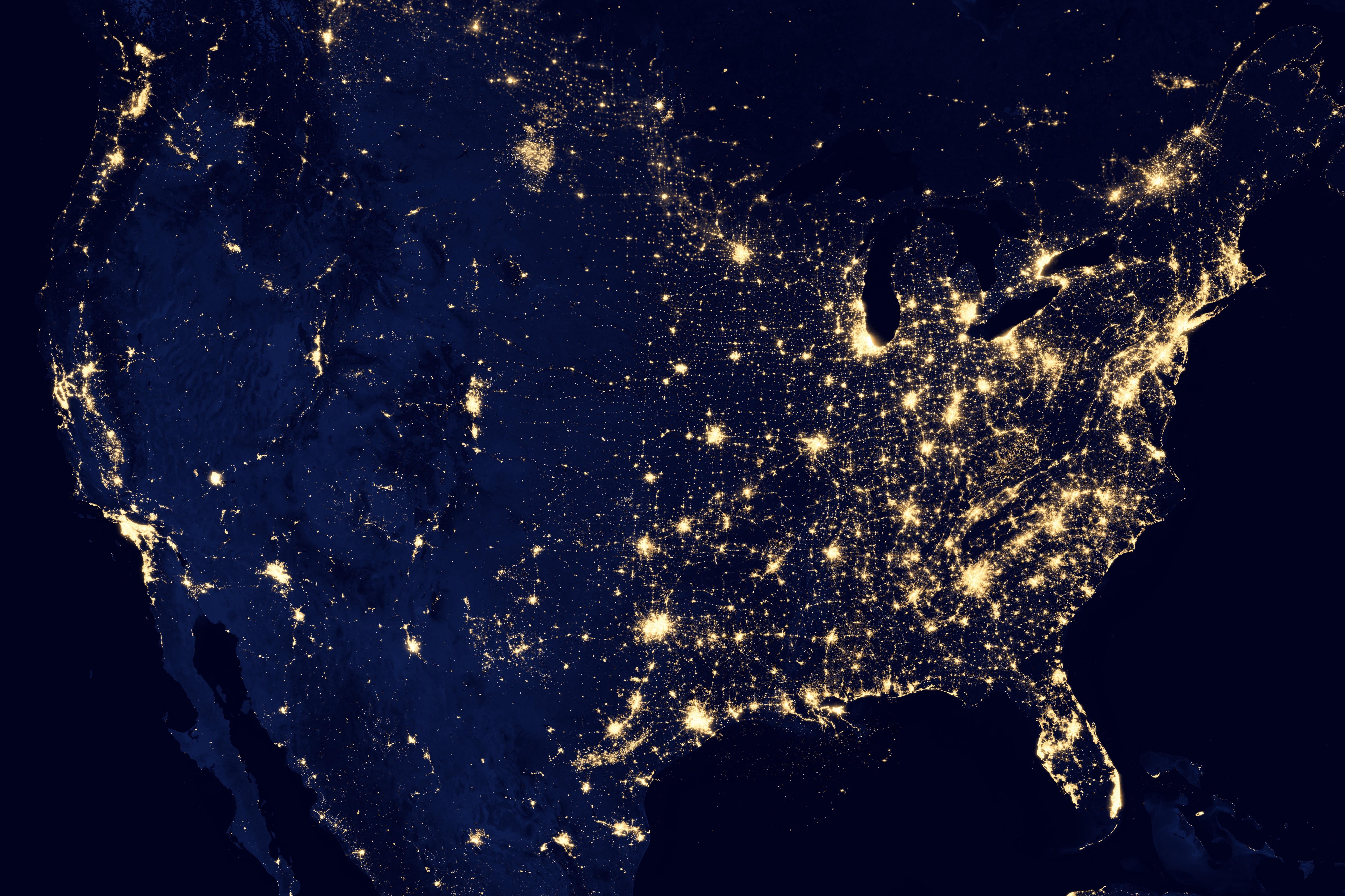
My understanding is that’s literally what a big chunk of North America looks like at night, when viewed from space with a sufficiently long camera exposure. This specific image may be composed of many exposures, but it’s not a cartogram or something; it’s a composite photograph.
Mostly you’re seeing electric lighting, which is clustered around places where people live and have the resources to light up their buildings and streets – so that people can see, drive, and be safe at night.
The picture is clearly at the very least a composite, because there are zero clouds anywhere. I was skeptical whether it can be called a “photo”. Given how clear the unlit terrain is, even in the ocean around the Bahamas for example, I thought it must have been a visualization, or a photo of daytime terrain shaded blue and overlaid with a map of nighttime lights. But I found the actual source: https://earthobservatory.nasa.gov/images/79765/night-lights-2012-map https://eoimages.gsfc.nasa.gov/images/imagerecords/79000/79765/dnb_land_ocean_ice.2012.13500x13500.B1.jpg
It really is a (composite) photo taken by the Suomi National Polar-orbiting Partnership satellite, whose cameras are so sensitive they can see reflected moonlight and “the nocturnal glow produced by Earth’s atmosphere”, albeit partially in the infrared.
This new image of the Earth at night is a composite assembled from data acquired by the Suomi National Polar-orbiting Partnership (Suomi NPP) satellite over nine days in April 2012 and thirteen days in October 2012. It took 312 orbits and 2.5 terabytes of data to get a clear shot of every parcel of Earth’s land surface and islands.
The nighttime view of Earth was made possible by the “day-night band” of the Visible Infrared Imaging Radiometer Suite. VIIRS detects light in a range of wavelengths from green to near-infrared and uses filtering techniques to observe dim signals such as gas flares, auroras, wildfires, city lights, and reflected moonlight.
I’m unsure though what “assembled from data” means exactly. At the very least the colors are artificial, shifted from the infrared-to-green range of the camera into human visual range. This page describes some more how the sensor functions, along with raw photos: https://earthobservatory.nasa.gov/features/IntotheBlack

My understanding is that’s literally what a big chunk of North America looks like at night, when viewed from space with a sufficiently long camera exposure. This specific image may be composed of many exposures, but it’s not a cartogram or something; it’s a composite photograph.
Mostly you’re seeing electric lighting, which is clustered around places where people live and have the resources to light up their buildings and streets – so that people can see, drive, and be safe at night.
It kinda shows the dominance humans have over the planet. We affect nearly every part of it. Nearly everything is light up by our lights.
To the point where it’s visible from space. From space, it’s as if we have altered all of the night’s topography.
Thanks
The picture is clearly at the very least a composite, because there are zero clouds anywhere. I was skeptical whether it can be called a “photo”. Given how clear the unlit terrain is, even in the ocean around the Bahamas for example, I thought it must have been a visualization, or a photo of daytime terrain shaded blue and overlaid with a map of nighttime lights. But I found the actual source:
https://earthobservatory.nasa.gov/images/79765/night-lights-2012-map
https://eoimages.gsfc.nasa.gov/images/imagerecords/79000/79765/dnb_land_ocean_ice.2012.13500x13500.B1.jpg
It really is a (composite) photo taken by the Suomi National Polar-orbiting Partnership satellite, whose cameras are so sensitive they can see reflected moonlight and “the nocturnal glow produced by Earth’s atmosphere”, albeit partially in the infrared.
I’m unsure though what “assembled from data” means exactly. At the very least the colors are artificial, shifted from the infrared-to-green range of the camera into human visual range. This page describes some more how the sensor functions, along with raw photos:
https://earthobservatory.nasa.gov/features/IntotheBlack