

Denverites should savor Wednesday’s warmth before this weekend starts to feel more like Christmas than Thanksgiving.
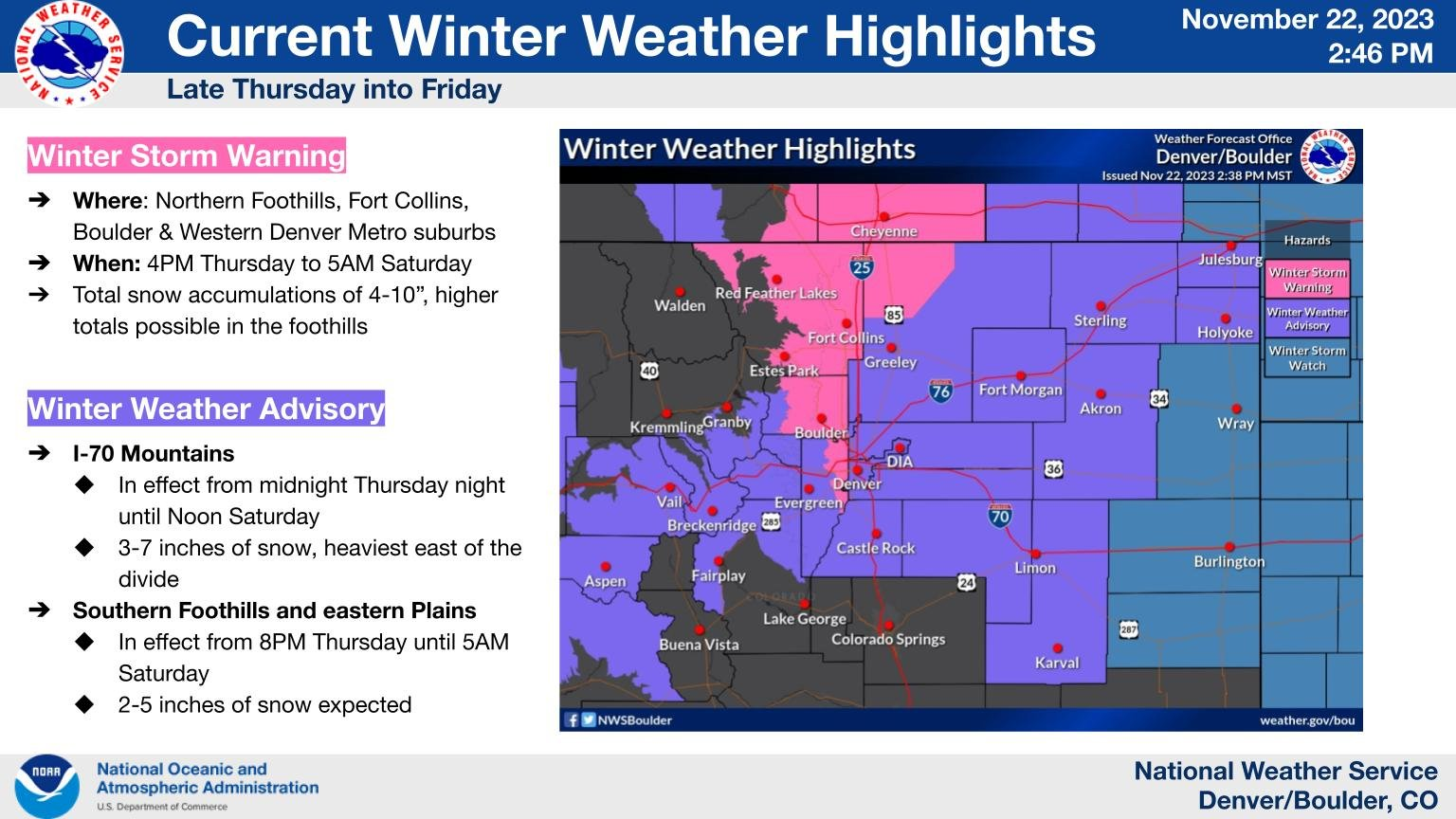
The unseasonably warm temperatures this week will plummet starting Thursday, and forecasters at the National Weather Service in Boulder said three to seven inches of snow could fall from Thursday to Saturday.
“Winter comes knocking on our doorstep for Thanksgiving day, with high temperatures plummeting around 25-30 degrees relative to Wednesday in the wake of a morning cold front,” Meteorologist Bruno Rodriguez said. The high Wednesday is 67 degrees, compared to Thursday’s high of 42 degrees.
Once the cold blows in Thursday, the focus turns to the snow.
There is still some variability in the amount of snow Denver could see, Rodriguez said, but the expected timing of the snow has stayed the same.
Skies — and roads — should stay mostly dry until just after sunset, then the snow will start to fill in.
“Once snow does initiate, cold temperatures and high snow ratios should allow for a quick transition to accumulating snow on roadways and thus slick conditions for all areas during the overnight period,” Rodriguez said.
Parts of the Denver metro could see between three and seven inches, with a 74% chance of at least two inches and a 39% chance of at least four inches in Denver. Forecasters said it is still too early to determine where in the metro area the most snow will fall.
If a sizeable amount of this forecasted snow falls on Thanksgiving day, this year could be among the top ten snowiest Thanksgivings in Denver.
Thanksgiving 1928 saw a record 8.5 inches of snow, and this year would only need to see .7 inches to be in the top ten. At least two inches would need to fall to be among to top five snowiest days.
Rodriguez said the weekend’s temperatures are of more concern than snow, however.
“Regardless of the exact snow amounts, the cold remains the real kicker, and confidence is high that temperatures will not climb out of the 20s both Friday and Saturday,” Rodriguez said. “With fresh snow cover, some single-digit lows will certainly be possible for parts of the plains and urban corridor Saturday morning.”
Friday and Saturday have nearly identical freezing forecasts in Denver, with highs of 26 degrees, lows of 15 degrees and snow expected both days.
With this frigid forecast, Denver will open two overnight shelters at the former Best Western hotel at 4595 Quebec St., now called New Directions, and at the Denver Coliseum Friday, Saturday and Sunday, the city announced in a news release.
The two shelters will be open from 7 p.m. to 7 a.m.
People needing shelter should go to the city’s “front door” shelter access points, Lawrence Street Community Center for men, Samaritan House for women, and Urban Peak for people aged 15 to 20. Those shelters will also have expanded capacity for the cold weather.
Families in need of shelter should call the Connection Center at 303-295-3366.