
You must log in or register to comment.
Anything more than 30 edges is bourgeois decadence
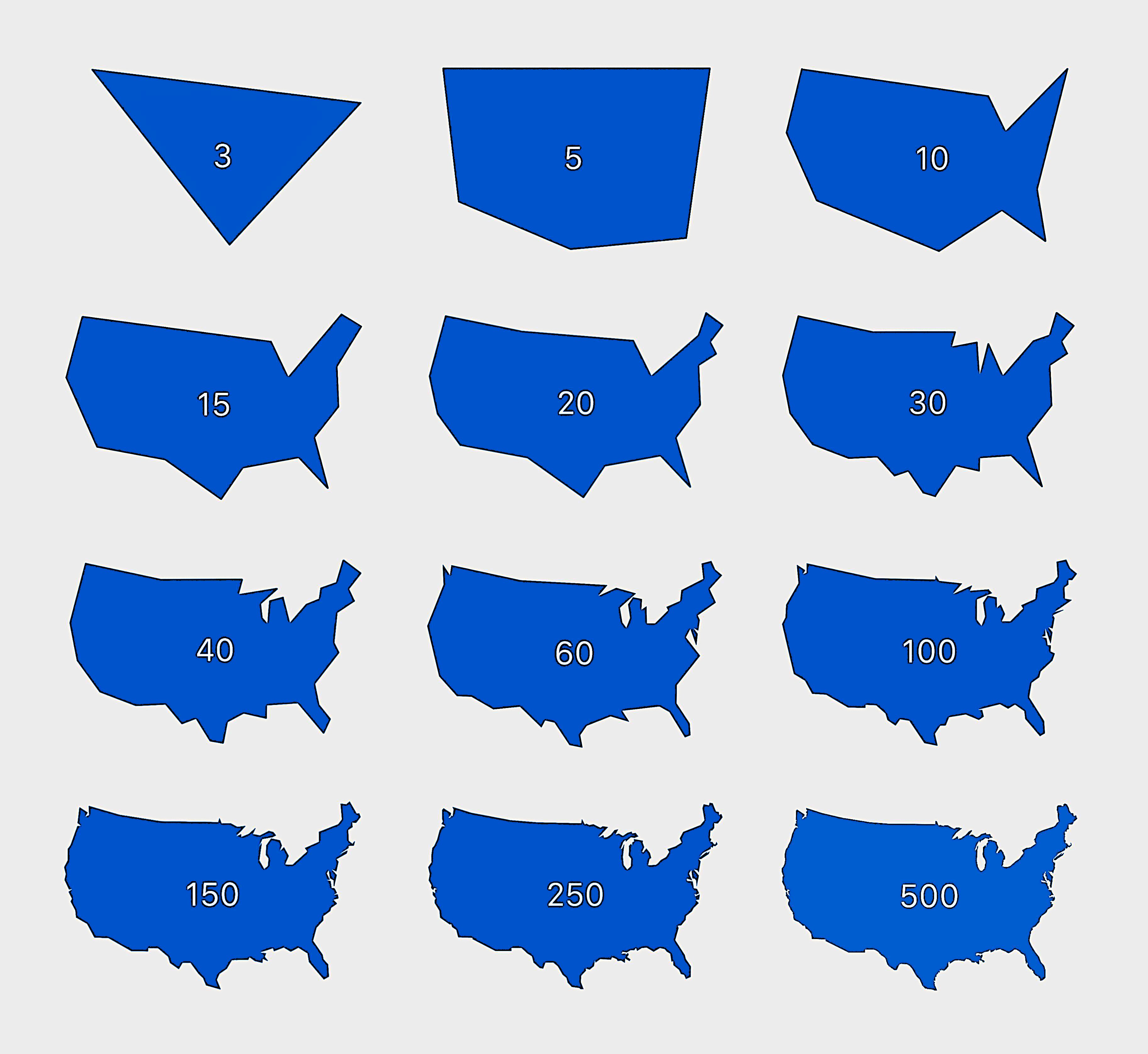
Hey now, Michigan’s mitten doesn’t appear properly until 60 and mittens are the glove of the common folk
Yeah but we look deadly tho
The gulags of the future will be coastal, so the prisoners can dig out every part of Florida that’s not almost perfectly north of Cape Sable.
Fidel would approve of the implications for Miami.
Video game deminishing returns in a nutshell
“Why is this cosmetics update 60 gigs?” -me
Bingo. Why do something with 15k vertices if 99% of the shape can be achieved with 700? Be kind to your player’s CPU ❤️
Not much of a distinguishable difference between 100 and 500. Pretty neat
10-15 is good enough. :)
the whale phase
This is Michigan erasure and I will not stand for it.
this is Michigan erasure and I’m all for it
Yup. At 10 I would get it after some number of fish related guesses - maybe just one. At 15 I’d instantly get it.
Florida, Great Lakes, Texas; boom, America.
Not at this scale. It might matter more if you lived in a coastline
How many miles of coastline does any country have? Depends.
What’s a systematic algorithm for finding the best approximation (minimal under/overshoot of area) when you are given a raster or vector image representing the “real” borders? Or it just trial and error?
For a raster image, you could count the number of true and false positive pixels and true and false negative pixels. Then use statistical metrics for binary classification, like sensitivity and specificity. I guess you could even make an ROC curve by measuring the true positive rate and false positive rate for varying number of edges in the model. I guess for a vector image you could do the same thing, just using the sum of overlapping and non-overlapping areas instead of pixel counts?
Oh I was thinking about something else and should have worded my question differently: for a given number of vertices, how do you find the coordinates that cover most of the area. So for instance for 3 vertices (triangle): where do you place the three points so that you cover as close as 100% of the area as possible? Overshooting would be allowed, ie a triangle that has an area of 120% of the US would be better than one that has 70%.
Yeah, i think minimizing the difference in area would be the primary goal, but you’d need to add additional constraints, like also minimizing the number of times that your edges cross the true perimeter, minimizing the non-overlapping area, or something like that. I dunno for sure, but this sounds like a fun problem. I might give it a shot this weekend. I’m in the early days of trying to learn rust (after years of pure python for work and school), and I’m always looking for toy problems to test myself with!
I’d imagine it would be a case by case basis.
Interesting that it’s already recognizable at 15.
It was nice at 5, but then Florida had to show up!
Fish
I dig 15 edge America
…fifteen gets the job done…
To be frank, I’m disappointed that there wasn’t a 50 edge version.
Now what’s the perimeter of each one?
Reminds me of this interesting phenomenon:
One important thing to note, because I see this a lot: this doesn’t mean coastlines are literally infinite in length; it’s a demonstration of how our current measurement system is flawed when it comes to coastlines. Coastlines can be measured in a way that’d make them finite, however the system works well enough that (it sounds like) no one has bothered to come up with a better, widely adopted alternative.
Also, I think I’ve read this can be applied to borders in general? That they use the same system for measuring the borders between countries, states, cities, etc. so any border could become infinite if the precision gets high enough.
Just fractal things. No matter how far you zoom in, it’s not going to be a smooth continuous function
Yes that is what I was thinking of
It’s cool that from 10 to 15 it goes from an amorphous blob to the USA so obviously.

Daddy shark do do do do
I find it interesting that (at least in my opinion) after 15 that I have to go all way to 40 before it seems like a solid improvement over what 15 offers.
Oh my god me too. 10 to 15 was drastic and the same with the jump to 40.


