
When I first tried OsmAnd a few years ago it was overwhelming, there is so much to customize.
I tried it again recently and it really impresses me.
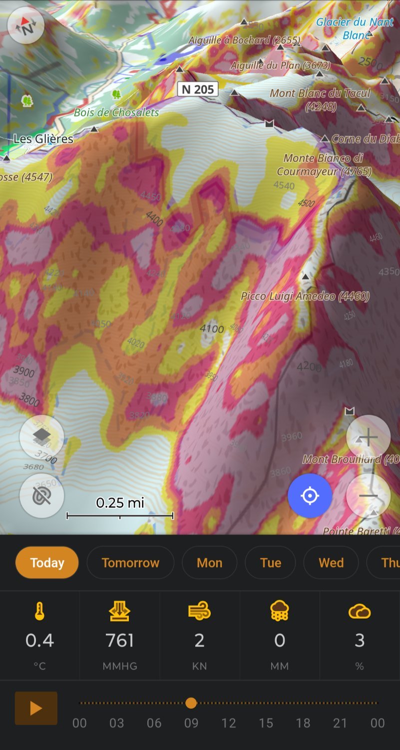
My OsmAnd ski profile shows me slope for avalanche risk and 3D relief so I don’t need Fatmap, plus OsmAnd let’s you download 7days of weather.
OsmAnd doing routing on hiking trails replaces my need for Gaia.
Really impressive work by the OsmAnd team.
It’s the best trails app I know. Has got me out of a pickle more than once.
This is the one Android app I have used without discontinuity since almost the very beginning. So, around 13 years. The team behind it are fairly well organised and responsive, and the app continues to improve steadily. The fact that so few normies have even heard of it is still a source of mystery to me. It’s a treasure.
The UI is rather old fashioned and complicated and scales badly, scaring people away before they start.
Best app on my phone
Wow, how did you get Osmand to look like this?
Not OP, but this looks like 3D Relief (requires OpenGL render) + Terrain (Avalanche mode) + Contour Lines + Weather Plug-in. My setup is quite similar, and I also have an optional satellite/aerial imagery layer, a Hiking map style, and quick actions set up to toggle all those on or off when I need to declutter the map. AFAIR all require Premium/Plus to use.
Here’s my profile if you want to quickly set it up in your app: https://share.balsoft.ru/OsmAnd-profile-balsoft.osf
You can share profiles?! Sweet thanks.
Oh I didn’t know you could setup quick options.
3D works for me without premium.
once i’ve fallen into osm pit, i can’t use google maps anymore, they’re effing braindead
Yep, happy that more and more people recognize it for a treasure of features and customization that it is. For me, it’s the best app for trekking, hiking, and offroading there is, even if we consider proprietary stuff like Fatmap and such.
I used it for the first time last week on a hike. It worked, but not intuitively at all. I had downloaded a GPX file which I imported in Osmand, and before I got the navigation working I had inadvertly added two waypoints.
Yeah it doesn’t have the friendliest user interface, but it does have an enormous amount of functionality when you eventually find the menu you are looking for.
The nice slick interface of Organic Maps makes me wish it loaded and zoomed smoother. But yeah the things you can do in OSMand as a fully offline app is incredible once it’s set up how you want it.
I wonder if there are simple interfaces, basically just a setup in osmand that simplifies it for people like my wife that does want complex
It is powerful enough that I reckon it can do it.
I contributed the “skiing” profile a few years ago :)
You pushed it to OsmAnd? Thank you!
I created the routing profile and put it online, some other person then took it and actually integrated it and got it merged. So, I did the fun part and they did the boring (but also important) work.
So I’m not able to claim the full credit, but close enough to get a lot of bragging rights.

