

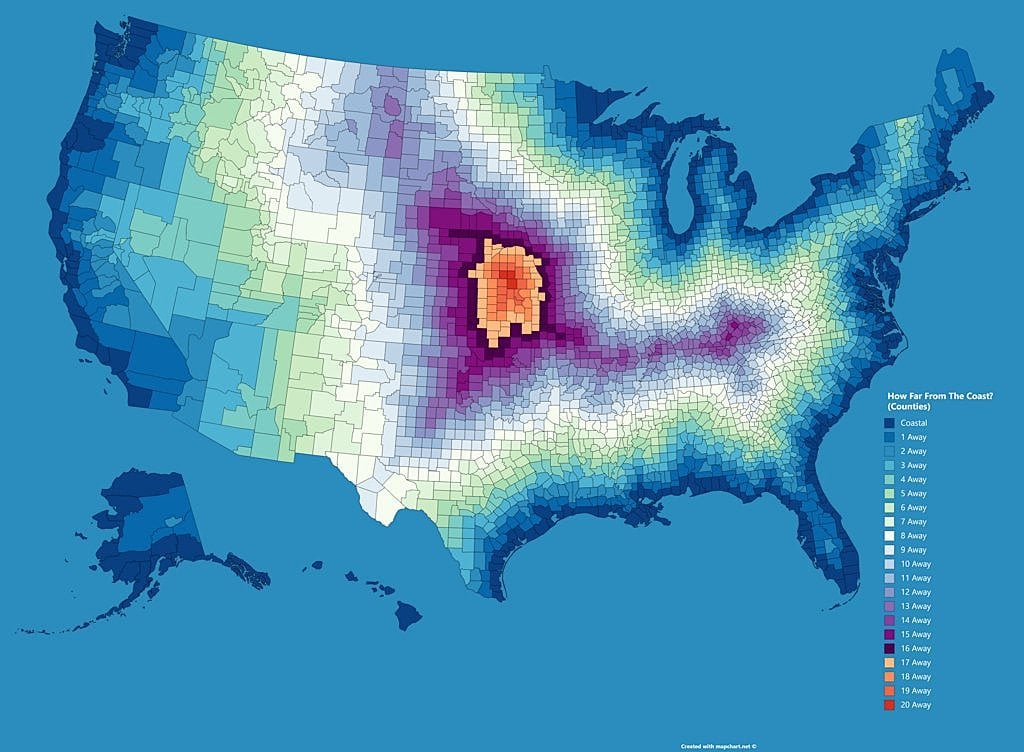
The measurement is “counties” away from the coast. Not miles nor km.
I realise now its literally in the title but for some reason the terminology did not compute and i just kept reading it as miles.
I thought there was something seriously off with this map or that it was a good example of the mercator distortion and had started to compare distances between cities.
Interestingly enough it wan ai (claude) that pointed this out from just the raw pic.
“The methodology of measuring by county units rather than strict distance creates an interesting visualization ”
it’s not in the title; if it were in the title, title would be Distance from the coast (by counties, in counties)
I am also very upset about the great lakes.
You mean the Michigan ocean?
The Big Water
Is the border of the great lakes really considered a coast?
Yes they are a type of coast, because of the size of the great lakes being comparable to seas even though they aren’t saltwater. It doesn’t meet the maritime concept, which is based on seas, but they are often referred to as either shores or coastline depending on context.
https://en.m.wikipedia.org/wiki/List_of_U.S._states_and_territories_by_coastline
they are also major ocean faring shipping lanes.
Seems sus to me. I get it, but then shouldn’t the shores of the Hudson River also be coast, and those counties counted as coastal counties?
St Lawrence is major. Hudson maybe not. Does get arbitrary.
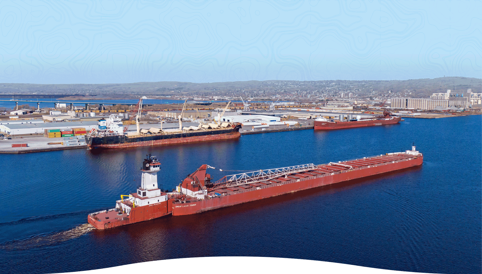
That’s an image from Duluth, MN, the furthest port in the Great Lakes from the ocean. You think boats that big making it up some dinky river? Clearly a coast
Also, the coast guard operates in the Great lakes as well
17+ amogus
“A” coast. This also makes a distinction between the Great Lakes and… every other lake in the US. It’s not salt water, because, well, the Great Lakes. So what determined whether a lake was big enough to qualify as having “a shore”? The Great Salt Lake in Utah is the 7th largest lake in the US (3 down from Lake Ontario, which is represented) and doesn’t appear to be be considered.
Are these “shores as US national borders, except for the shores of rivers?”
The great lakes are large enough to not see the other shore/coast due to the curvature of the Earth and they are on an external border which makes them comparable to inland seas despite being freshwater.
The great lakes are comparabke to the Red Sea or Black Sea.
Also if I am not mistaken - aren’t there ships that go both on the Great Lakes and the open ocean? That could be a possible criterion. Most lakes don’t have ocean-going ships.
That was how I was assuming the rationale went. You do see ocean going vessels on the Great Lakes.
https://en.wikipedia.org/wiki/St._Lawrence_Seaway
And I think that’s how everyone wound up with the zebra mussels. (Bilge discharge from those ships)
The great salt lake doesn’t connect to the ocean or any other shore and therefore is not a major shipping route. Also it may only be two more down than Ontario but it’s an order of magnitude smaller.

So, the definition is “a body of water from which one can navigate - even if by river or canal - to an ocean”? How big does the traversal have to be - if I can get there by canoe without portage, does that count? What about Lake Eirie? AFAIK, you can’t navigate without portage from Eirie to the Atlantic, but it connects to Lake Ontario via the Niagara River.
The map doesn’t count the Mississippi river, it’s not about ship navigation.
It’s a bad map, but it makes sense and calling the great lakes a coast isn’t that weird.
Any arguments to have to follow up are pointless and will fall on deaf ears, I don’t really care about your protests.
Okay. I don’t think it’s a bad map; I think it would have helped to define what counts as “a coast,” is all.
…international coastlines; shores with ports-of-entry…
That’s interesting and random. I think time to coast would be a better measure and look quite a bit different, especially seeing as this map counts the Great Lakes as “coastal”, which I don’t think fits the definition. The lakes are called the “third coast” jokingly, but coastal is seashore, not freshwater.
Now I want a breakdown of how people in an area refer to locations near them such as using counties or cities.
Here in western North Carolina we use counties but my friends in eastern NC don’t. I figure it’s because a lot of towns out here are too small to even be towns most of the time.
When I went to school in West Virginia the locals also used counties there when referring to where they’re from.
I know using counties is popular in California and looking at the map I can kinda see why since they’re huge.
It’s like the electoral map
I think if you plotted political inclination as a function of distance from coast, globally, you might find quite a good correlation. Various plausible explanations. For example, in tougher mid-continental climates you need to store and protect stuff to survive the winter / dry-season, so people there evolved (including self-filtering migration) to have more tribal loyalty.
Hmm always thought it’s cause big cities need big fresh water, that’s why there’s a good chance that historically they formed near streams/lakes. Typically near the coast rivers slow down and branch out, giving good access to natural resources and also trade. Trade increases prosperity and exposure to other cultures.
Indeed trade links relevant, so navigable rivers played a big role - before railways, our main transport was either boats or horses (or camels). Horses needed a lot of grass, which thrives in drier mid-continental climates where trees don’t survive wildfires. For example the Mongol empire was good at trade and connecting cultures, covered a huge area, but not (for long) near coasts, and still demanded intense tribal loyalty (elements of such culture was absorbed by the next empire which gradually pushed it back…).
Driving time distance from any interstate highway would reveal regions most likely to attempt seceding from the Union.
Can you do Canada? With Lake Winnipeg and Slave lakes big enough to count?
Eh, We cant do canada. Sorry.
I wish the state boundaries were a bolder line overlay
I’ll never understand ’Muricans and their fetish for rulers.
[Edit: To clarify: I’m talking about the crazy straight borders.]
Why are you in the map community if you don’t like measuring things
There’s something they especially hate measuring. So they apply that same hatred to all measurements.
Are you more of a compass man?
Much better!


