

Damn, Ukraine really went crazy with its 2026 counteroffensive.
From the Sea to the Sea to the Sea to the Sea to the Sea
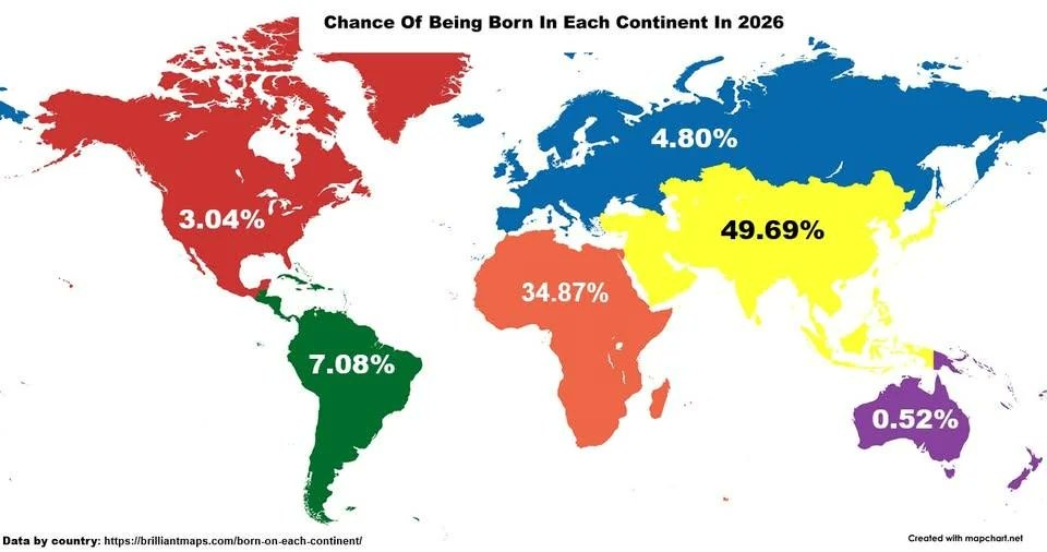
“Wait, it’s all Ukraine?”
“Always has been.”
🧑🚀🔫🧑🚀
Slava Ukraini Intensifies
Angry Albanian Noises
Inclusive ports representing all water temperatures.
I was already born, so my chances of being born elsewhere are actually much lower, I think
Someone doesn’t know about the great rebirth of 2026.
It’s the next logical step after so many Raptures, ya know? 🤷🏼♂️
Is this caused by the covid vaccine?
Death is on the rise, as is India’s GDP. So don’t rule out reincarnation.
That’s an odd way to divide it up. Without Mexico, the US would be much, much lower. Every continent map shows Russia as part of Asia.
For this specific purpose it probably does make sense to consider Russia part of Europe. If we go by the common Europe-Asia dividing line of the Ural mountains then a large majority of Russia’s population is in the European half, so most Russian births are probably in the European bit
The weird thing about the Americas to me is that only Mexico, the US, and Canada are counted. I don’t think I’ve ever seen anyone that draws a dividing line between North and South America do so anywhere except at the Darien Gap, nor have I seen anyone put all of the Caribbean islands in South America. Iberoamerica or similar cultural region terms, sure, but South America the continent?
It’s a very mixed bag on this map, since it was labeled “continent” but they separated Russia.
Well, the person that made this is making russia very happy that they they are now European, lol.
As I understand it, Russia actually tends to reject the notion of a separate Europe and Asia. They prefer a six-continent model with Eurasia as one thing
I prefer to be a billionaire, but it’s not how it is.
Maybe, as the capital of russia is in Europe, russia is counted as Europe, while Turkey is counted to Asia, as its capital is in its Asian part.
So every continent map is wrong?
Yes. Continent is a dubious cultural term, not geographical. See map men’s genial video on the topic: https://www.youtube.com/watch?v=hrsxRJdwfM0
Or CPG Grey’s video: https://www.youtube.com/watch?v=3uBcq1x7P34
Well, yeah. The definition of “continent” is arbitrary.
I could argue that there are only four, for instance (America, Afro-Eurasia, Antarctica, and Australia).
And then at that rate, Greenland could be counted, or Australia and Antarctica left out.
Well yes, it is entirely arbitrary. One of the most agreed-upon factors is that “at least as big as Australia” is a requirement, but there’s no hard reason for that requirement
Personally I think we should consider particarly big mountain ranges and deserts as continental boundaries more often, like we do with the Urals in nodels that separate Asia and Europe. “Asia” is such a huge concept as to be almost useless, and it’s not like China and Arabia had much influence on each other historically
You do have “regions” already kind of filling that niche. MENA, Europe, Central Asia, East Asia and so on.
We just need better branding for them! Middle East and North Africa doesn’t roll off the tongue nearly as well as just Africa
and i would argue there are way more, because grouping all of africa and europe and asia together is kind of utterly pointless.
What makes sense to me is groupings very much like europe in size and cultural cohesion, something roughly like this:

(I can’t intuitively figure out where to draw lines in america, aside from the fact that the northern part of the landmass is basically unpopulated and vastly more similar to greenland than it is to the populated parts)
Siberia is not part of Europe you weirdos.
One could say the map simply counted transcontinental countries as where the majority of the population lives, but French Guiana isn’t colored like Europe.
Also interesting that the southern border of Mexico is apparently the border between North and South America.
Yeah the most interesting thing about this map is the weird biases on display.
Personal guess?
This was made by a white supremacist to try and push replacement theory/14 words type fears without tipping off the normies
Removed by mod
It’s part of Afroeurasiaca
I’m sure the massive number of people being born in Siberia makes this map completely useless /s
I choose to not be born in 2026
Brave
Looks at Australia

deleted by creator
I think PNG is usually considered a part of Oceania and Indonesia a part of Asia, which is why it stands out. What borders are not intact?
Can I haz data source and computation approach pleaze?
Isn’t it birth rate times population (normalized to world total births)? Then you draw the borders where you want…
For any parents trying to find their new baby, starting the search in Asia seems like a good strategy! Book a flight immediately after birth.
I’d immagine it being 0% across the world, it is still 2025…
Babies gestate for 9 months.
Amateurs. I did it in 8.
Now do “chance of dying of any cause under the age of 20” per continent.
so you want an industrialization index?
Wait when was Russia part of Europe.
since 80% of its population was in the european side
Ive been lied to my whole life!
Western part is in Europe, east of the Caucasus mountains is Asia. Map is slightly ehh in that regard.
I think you might be confusing the Ural Mountains with the Caucasus Mountains?
Russia west of the Ural mountains is Europe, east is Asia. But the Caucasus mountains are also a border between Europe and Asia.
Thus proving the almost total arbitrariness of defining Europe as a “continent” but here we are.
That’s how the Romans divided the world thousands of years ago and it stuck.
Yea sorry, it’s been over a decade since I last had Geography class lmao
New year’s resolution: beat the odds and be not born in Asia.
Technically the odds would be with “not born in Asia”, 50.31%.
Nobody ever said new year’s resolutions have to be difficult.
Of course the europe-asia border is wrong, but the south america -north america border is wrong as well. It should be where Panama is.
I see a lot of US Americans think that north America only has 3 countries. That’s false.
Trump’s delusions about Greenland seem to be contagious to whoever color-coded this map.
I see a lot of US Americans think that north America only has 3 countries. That’s false.
Three countries is what I was taught in school in the 80s and 90s. And that the Americas are 3 continents; North, Central, and South America.
What was the reasoning back then for singling out central America?
*on preferably


